
ArcGIS Solutions for Government - Meet ups 
State and local government GIS users can benefit from the ArcGIS Solutions for Government Meet Ups. These videos provide comprehensive tutorials and tips to help users get the most out of their GIS systems. They cover topics such as data management, mapping, and analysis. With these resources, government GIS users can maximize their efficiency and accuracy. ▼
ADVERTISEMENT
Course Feature
![]() Cost:
Cost:
Free
![]() Provider:
Provider:
Youtube
![]() Certificate:
Certificate:
Paid Certification
![]() Language:
Language:
English
![]() Start Date:
Start Date:
On-Demand
Course Overview
❗The content presented here is sourced directly from Youtube platform. For comprehensive course details, including enrollment information, simply click on the 'Go to class' link on our website.
Updated in [February 21st, 2023]
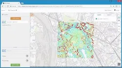
ArcGIS Solutions for Government - Meet ups is an excellent resource for GIS users in state and local government. This course provides comprehensive tutorials and tips for GIS users to help them better understand and utilize the power of GIS. It covers topics such as ArcGIS, government solutions, mapping, data analysis, and geospatial analysis. The course also includes meet ups and other resources to help GIS users stay up to date with the latest trends and technologies. This course is ideal for GIS users who want to gain a better understanding of GIS and its applications in government. It is also a great resource for those who want to learn more about GIS and its potential for government solutions.
[Applications]
After completing this course, users of ArcGIS Solutions for Government can apply their knowledge by attending local meet ups to network with other GIS professionals. They can also use the tutorials and tips to create their own GIS projects and share their work with the community. Additionally, users can use the resources to stay up to date on the latest GIS trends and technologies.
[Career Paths]
1. GIS Analyst: GIS Analysts are responsible for analyzing geographic data and creating maps and other visualizations to help government agencies make informed decisions.
2. GIS Developer: GIS Developers are responsible for developing and maintaining GIS applications and databases. They use ArcGIS software to create custom applications and databases for government agencies.
3. GIS Technician: GIS Technicians are responsible for maintaining and troubleshooting GIS systems.
4. GIS Manager: GIS Managers are responsible for managing GIS projects and teams.
Course Provider

Provider Youtube's Stats at AZClass
Discussion and Reviews
0.0 (Based on 0 reviews)
Explore Similar Online Courses

The Complete Guide To Instagram Hashtags: Increasing Hashtag Reach

Flutter & Firebase App Build Flutter WEB iOS & Android CRUD App - Flutter 25 Tutorial for Beginners 2021 with Flutter Null Safety - ToDO List App

Python for Informatics: Exploring Information

Social Network Analysis

Introduction to Systematic Review and Meta-Analysis

The Analytics Edge

DCO042 - Python For Informatics

Causal Diagrams: Draw Your Assumptions Before Your Conclusions

Whole genome sequencing of bacterial genomes - tools and applications

Deep Learning
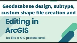
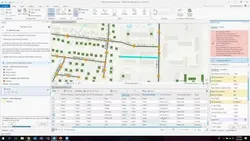
How to create new shape file and geodatabase in ArcGIS
Start your review of ArcGIS Solutions for Government - Meet ups