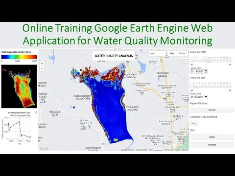
Online Training on Google Earth Engine for Air & Water Quality Monitoring using Remote sensing 
This 3-day online training program on Google Earth Engine for Air & Water Quality Monitoring using Remote sensing techniques is the perfect opportunity to learn the necessary skills to start using GEE for your remote sensing analysis. With a fee of 500 dollars, the first 5 registered people get a 50% discount of only 250 dollars. Learn how to map O3, NO2, SO2, HCHO, CHOCHO and aerosols, CO, CH4, and stratospheric O3 density, make time-series charts, download air quality parameters time series data in CSV format, convert units, export maps, and more. Also, learn about NDTI, NDCI, NDWI, AWEI, TSS remote sensing model, turbidity remote sensing model, chlorophyll, and time series chart for TSS, turbidity, and chlorophyll. Take advantage of this discount and register now! ▼
ADVERTISEMENT
Course Feature
![]() Cost:
Cost:
Free
![]() Provider:
Provider:
Youtube
![]() Certificate:
Certificate:
No Information
![]() Language:
Language:
English
Course Overview
❗The content presented here is sourced directly from Youtube platform. For comprehensive course details, including enrollment information, simply click on the 'Go to class' link on our website.
Updated in [July 25th, 2023]
Registration is now open for a three-day online training program on Google Earth Engine for Air & Water Quality Monitoring using Remote Sensing techniques. The class will begin on the 29th of December and the last date for admission is the 20th of December, with the last date for booking being the 16th of December. Each day of the class will last three hours. The program fee is 500 dollars, but the first five registered people will receive a 50% discount of only 250 dollars. There is only one seat available for this discount, so take advantage of this offer and register quickly! Payment can be made from any country using Western Union or Money Gram, using the provided information. Alternatively, payment can be made directly to the provided bank account. After payment is completed, the receipt should be sent to the instructor, who will then add the participant to the online training WhatsApp group.
This course will teach participants all the necessary skills to start using GEE for their remote sensing analysis. It is mainly focused on those who do not know any programming language or Earth Engine functions. After completing the course, participants will be able to do any Remote Sensing analysis quickly and efficiently using the Google Earth Engine Platform. Topics covered include LULC mapping, Air quality monitoring, Time series analysis, Calculating indices, Supervised Classification, Machine Learning Methods, and more.
For Air Quality Monitoring, the course will cover O3, NO2, SO2, HCHO, CHOCHO and aerosols, CO, CH4, and stratospheric O3 density mapping using Google Earth Engine, how to make time-series charts, how to download Air Quality parameters Time series data in CSV format using Google Earth Engine, how to convert this unit mol/m2 to molecules/cm3, and how to export this Map and use ArcMap.
For Water Quality Monitoring, the course will cover NDTI: Normalized Difference Turbidity Index, NDCI: Normalized Difference Chlorophyll Index, NDWI: Normalized Difference Water Index, AWEI: Automated Water Extraction Index, TSS remote sensing Model, Turbidity remote sensing Model, Chlorophyll, Time series Chart for TSS, Turbidity, and Chlorophyll, and how to make the time series change Animation.
Participants are encouraged to join the GISRS Institute YouTube channel, the StudyHacks Education Facebook page, and the GIS and Remote Sensing Learning Telegram group.
Course Provider

Provider Youtube's Stats at AZClass
Discussion and Reviews
0.0 (Based on 0 reviews)
Explore Similar Online Courses

Google Earth Engine Python API for Absolute Beginners

HOW TO START A CREDIT REPAIR BUSINESS Part 1 BEGINNER FRIENDLY LifeWithMC

Python for Informatics: Exploring Information

Social Network Analysis

Introduction to Systematic Review and Meta-Analysis

The Analytics Edge

DCO042 - Python For Informatics

Causal Diagrams: Draw Your Assumptions Before Your Conclusions

Whole genome sequencing of bacterial genomes - tools and applications
![FULL COURSE - Google Earth Engine Python API and Colab for Absolute Beginners in 3 Hours [2023]](/ccsimg/dcs/img_tools/421c1f0f124cdd4dc138ffbea8f3d287.webp)
FULL COURSE - Google Earth Engine Python API and Colab for Absolute Beginners in 3 Hours [2023]

Importing GIS shapefiles into Google Earth Engine


Start your review of Online Training on Google Earth Engine for Air & Water Quality Monitoring using Remote sensing