
Soil erosion spatial modeling with RUSLE in ArcGIS software 
This course will teach you how to model soil erosion of any given study area with the RUSLE (Revised Universal Soil Loss Equation) model in the widely used ESRI ArcGIS software. You will learn how to make a spatial map of soil loss for any study area you want, without the need for field data. You will also master tools such as supervised classification, NDVI map, hydrologic analysis, model builder, and more. This course is easy to follow and is beneficial for soil scientists, agricultural scientists, earth scientists, environmental scientists, and more. With this course, you will be able to make a spatial map of soil loss for any study area you want, applying the most widely used soil erosion model in the world. ▼
ADVERTISEMENT
Course Feature
![]() Cost:
Cost:
Paid
![]() Provider:
Provider:
Udemy
![]() Certificate:
Certificate:
Paid Certification
![]() Language:
Language:
English
![]() Start Date:
Start Date:
2023-04-14
Course Overview
❗The content presented here is sourced directly from Udemy platform. For comprehensive course details, including enrollment information, simply click on the 'Go to class' link on our website.
Updated in [July 25th, 2023]
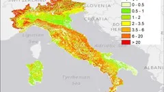
In this course, students will learn to model soil erosion of any given study area with the RUSLE (Revised Universal Soil Loss Equation) model in the widely used GIS software ESRI ArcGIS. The course is divided into six sections, with the initial five sections referring to each parameter of the model - R (soil erosivity), K (soil erodibility), LS (slope length), C (land use and land cover), and P (crop management) factors. No field data is required; only the software and internet access are needed to execute the final map of soil erosion. With this course, students will be able to make a spatial map of soil loss for any study area they choose, applying the most widely used soil erosion model in the world. Initial knowledge of ArcGIS and basic knowledge of geoinformatics are welcomed, but not necessary. In addition to modelling, students will also master such tools as supervised classification, NDVI map, hydrologic analysis, model builder, and other useful tools. The course is easy to follow and accomplish, and is beneficial for specialists such as soil scientists, agricultural scientists, earth scientists, environmental scientists, etc. Many course works and bachelor and master dissertations in universities include research on soil erosion spatial modelling.
Course Syllabus
Introduction
Fundamental theory
R factor (Rainfall erosivity)
K factor (Soil erodibility)
LS factor (Slope length)
C factor (Land use and land cover)
P factor (Conservation practice factor)
Final water erosion modelling with RUSLE
Course Provider

Provider Udemy's Stats at AZClass
Discussion and Reviews
0.0 (Based on 0 reviews)
Explore Similar Online Courses

Digital Computer Electronic Engineering Circuit Simulations

Real Estate Photography Masterclass: Your Complete Guide

Python for Informatics: Exploring Information

Social Network Analysis

Introduction to Systematic Review and Meta-Analysis

The Analytics Edge

DCO042 - Python For Informatics

Causal Diagrams: Draw Your Assumptions Before Your Conclusions

Whole genome sequencing of bacterial genomes - tools and applications
ArcSWAT Model with ArcGIS - Run for any Study Area - GIS

Rainfall Threshold for Landslides Prediction with Excel only
Start your review of Soil erosion spatial modeling with RUSLE in ArcGIS software