
Spatial mapping of water erosion with MCDA tool in ArcGIS 
This course is a great opportunity for students to learn how to use GIS and Analytical Hierarchy Process (AHP) to map water erosion susceptibility. It covers the theory and practice of preparing thematic layers for any study area, and assigning weights to seven layers that directly influence water erosion. The results of this course can be used for thesis dissertation, publication of an article, or conducting a research project. It is suitable for both beginners and those with intermediate knowledge of GIS and soil science, and is easy to learn and apply. Don't miss out on this chance to gain valuable knowledge and skills to help you understand and map water erosion! ▼
ADVERTISEMENT
Course Feature
![]() Cost:
Cost:
Paid
![]() Provider:
Provider:
Udemy
![]() Certificate:
Certificate:
Paid Certification
![]() Language:
Language:
English
![]() Start Date:
Start Date:
2022-02-12
Course Overview
❗The content presented here is sourced directly from Udemy platform. For comprehensive course details, including enrollment information, simply click on the 'Go to class' link on our website.
Updated in [July 25th, 2023]
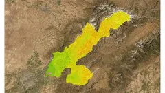
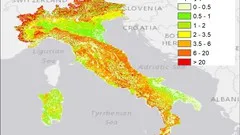
This course provides students with an easy to learn and apply guide to spatial mapping of water erosion with the use of MCDA tool in ArcGIS. It is designed to help students understand and apply GIS instruments and Analytical Hierarchy Process (AHP) to delineate areas that are highly or low susceptible to water erosion. Water erosion is a widespread phenomenon that can cause a variety of negative consequences to the environment and human activity, including damage to agricultural productivity, reduction of soil fertility, and harming biodiversity. AHP is the most widely applied multi-criteria decision analysis tool and is used for multiple purposes during GIS analysis, including soil erosion modeling. In this course, AHP will be used to assign weights for seven thematic layers that directly influence water erosion. These layers include land use and land cover, precipitation, slope, curvature, topographic wetness index, soil texture, and stream proximity. The course will teach students to prepare all those thematic layers for any study area. Upon completion of the course, students will be able to create a map of water erosion susceptibility for any study area and understand the factors causing soil erosion. The results can be used for thesis dissertation or publication of an article, as well as conducting a research project. The course includes both theory and practice lectures, with a focus on the latter (80%). It is suitable for both beginners and those with an intermediate knowledge of GIS and soil science.
Course Syllabus
Introduction
Basic theory on soil erosion
Multi-criteria decision analysis tool
Analytical hierarchy process (AHP)
Data for the project
LULC thematic layer
Slope thematic layer
Curvature thematic layer
Topographic wetness index thematic layer
Stream proximity layer thematic layer
Soil texture thematic layer
Precipitation thematic layer
Water erosion mapping with AHP in ArcGIS
Map presentation in ArcGIS
Course Provider

Provider Udemy's Stats at AZClass
Discussion and Reviews
0.0 (Based on 0 reviews)
Explore Similar Online Courses

Google Analytics: How To Get Certified (GAIQ test)

Historical Airphoto Processing (HAP) with PCI Geomatics

Python for Informatics: Exploring Information

Social Network Analysis

Introduction to Systematic Review and Meta-Analysis

The Analytics Edge

DCO042 - Python For Informatics

Causal Diagrams: Draw Your Assumptions Before Your Conclusions

Whole genome sequencing of bacterial genomes - tools and applications

ArcSWAT Model with ArcGIS - Run for any Study Area - GIS
Soil erosion spatial modeling with RUSLE in ArcGIS software

Start your review of Spatial mapping of water erosion with MCDA tool in ArcGIS